Veteran Health Compass
How far every Veteran drives to VA care, and what would bring it closer.
A national map of Veterans’ drive times to the nearest VA medical center or clinic. It shows where the long drives are, then lets planners test a mobile unit or pop-up clinic, a telehealth access point or a partner clinic and see how many Veterans each would bring within 30 minutes.
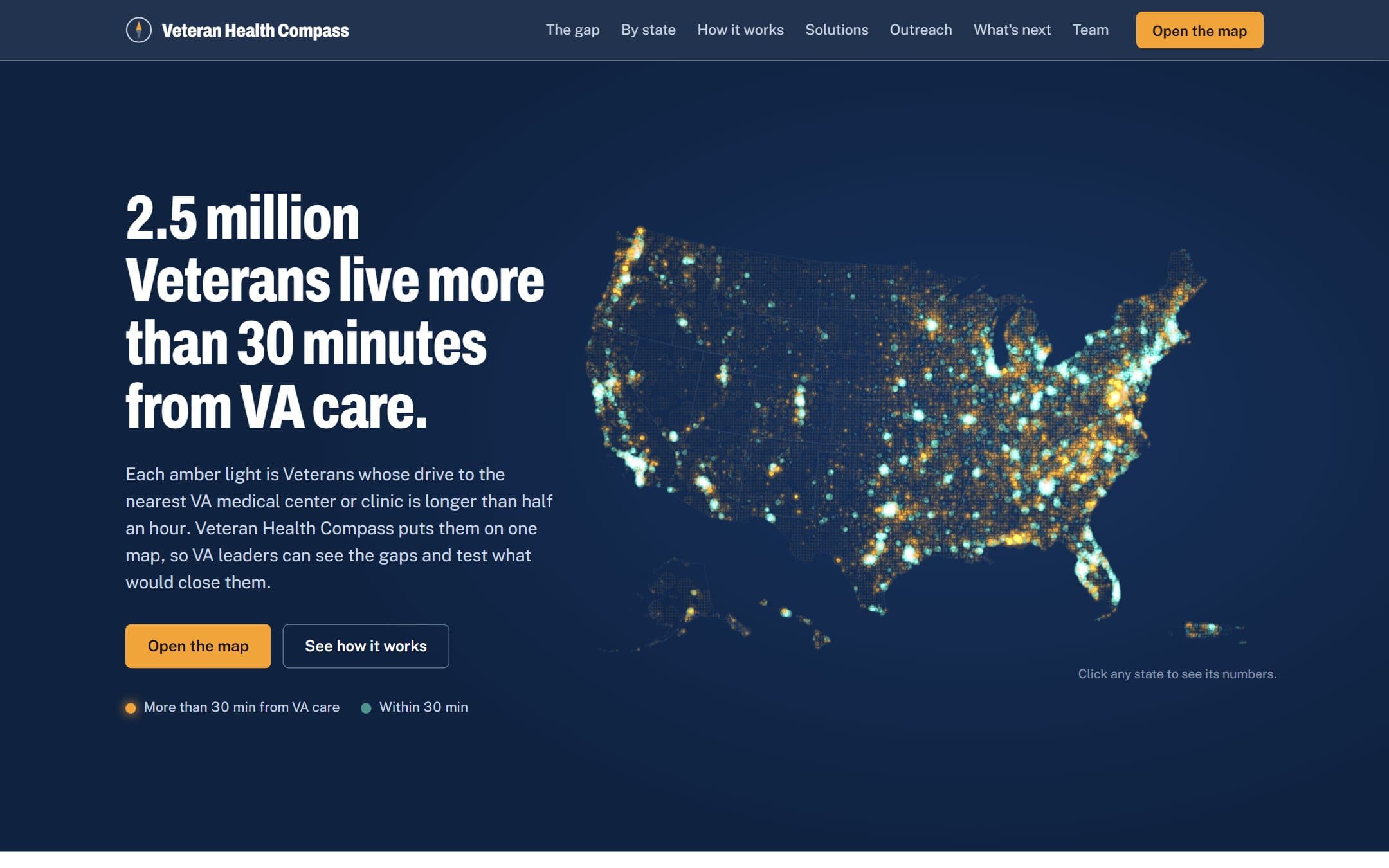
Each amber light is Veterans whose drive to VA care is longer than half an hour.
2.5M
Veterans who live more than a 30-minute drive from VA care
17.3M
Veterans mapped by real road drive time
53
states and territories, each with its own map
11.8M
Veterans who didn’t use VA health care in FY2023, mapped by county
The problem
Distance is the barrier you can map
Most access reports count Veterans by county or measure straight-line distance. Neither says how long the drive actually is. A Veteran across a bay or at the end of a two-lane road can be close on a map and over an hour away by car.
Veteran Health Compass measures real road drive time for every Veteran, in every state, and turns that into decisions: where the largest gaps are, which fix closes each one for the least money, and where Veterans who aren’t using VA care live.
How it works
From Veterans to drive times to decisions
01
Place every Veteran
VA VetPop2023 county counts are spread to Census tracts and grouped into 2.5-mile hexes.
02
Measure the drive
Real ArcGIS road-network drive-time areas around every VA site, including sites just across a state line.
03
Test a fix
Drop a mobile unit, telehealth point or partner clinic and see how many Veterans it brings within 30 minutes, and what it costs.
The map
Every state, by drive time
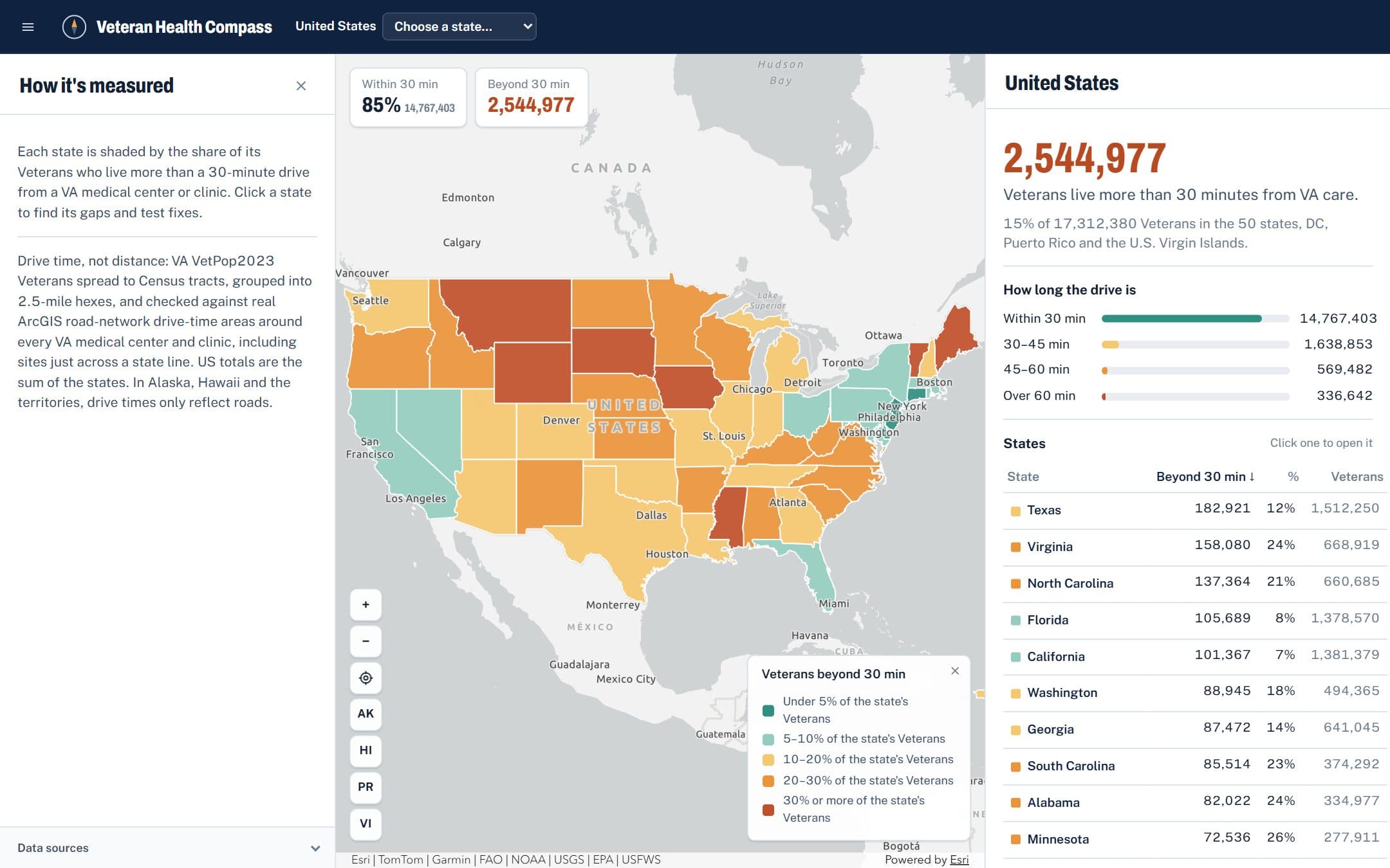
The national view ranks states by how many Veterans live beyond 30 minutes. Open one to see its hexes, VA sites and largest gaps.
Gaps and fixes
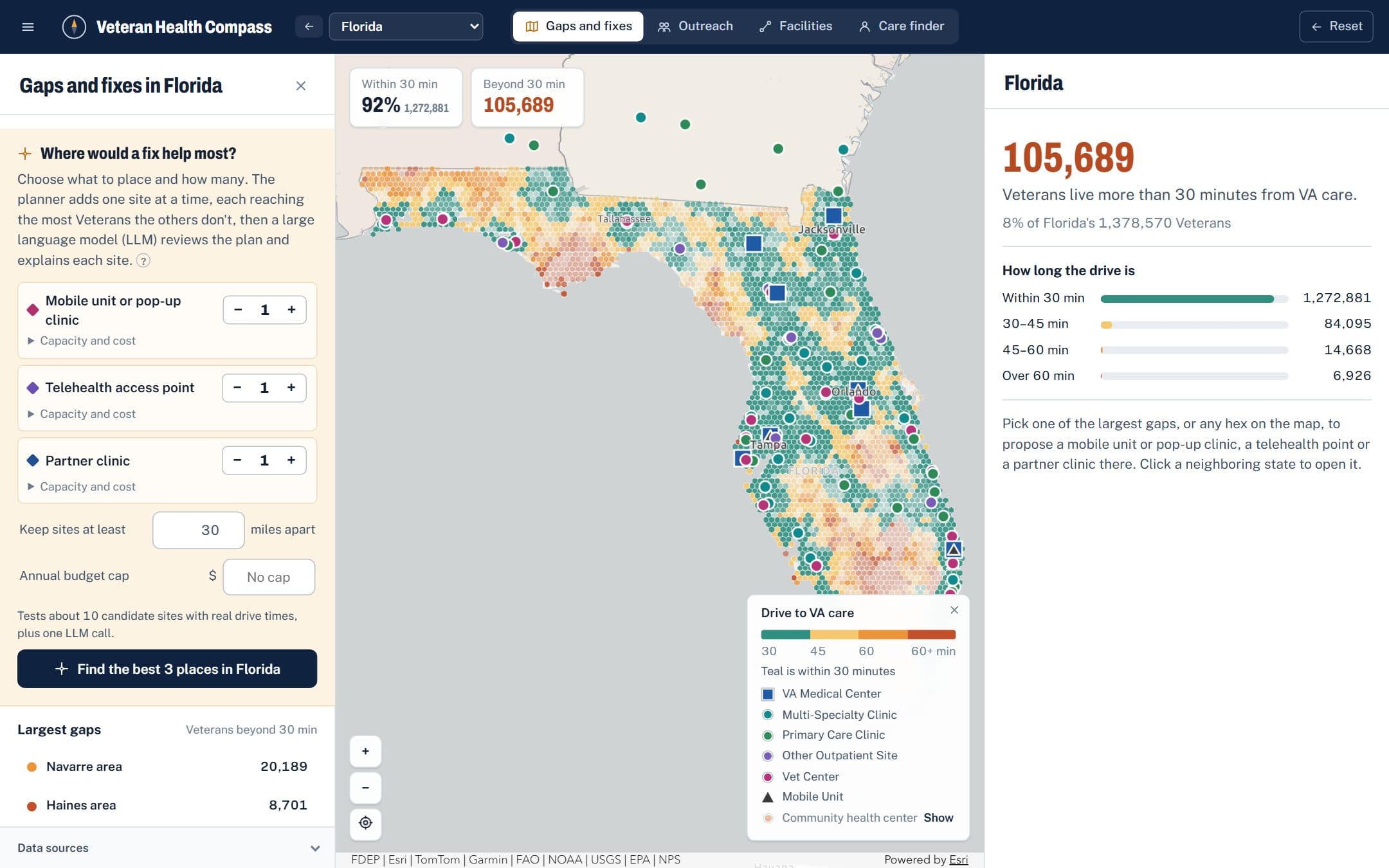
Find where a fix helps most
Set how many of each option to place, how far apart and on what budget. A planner adds one site at a time, each reaching the most Veterans the others don’t, then an LLM reviews the plan and explains each pick.
Outreach
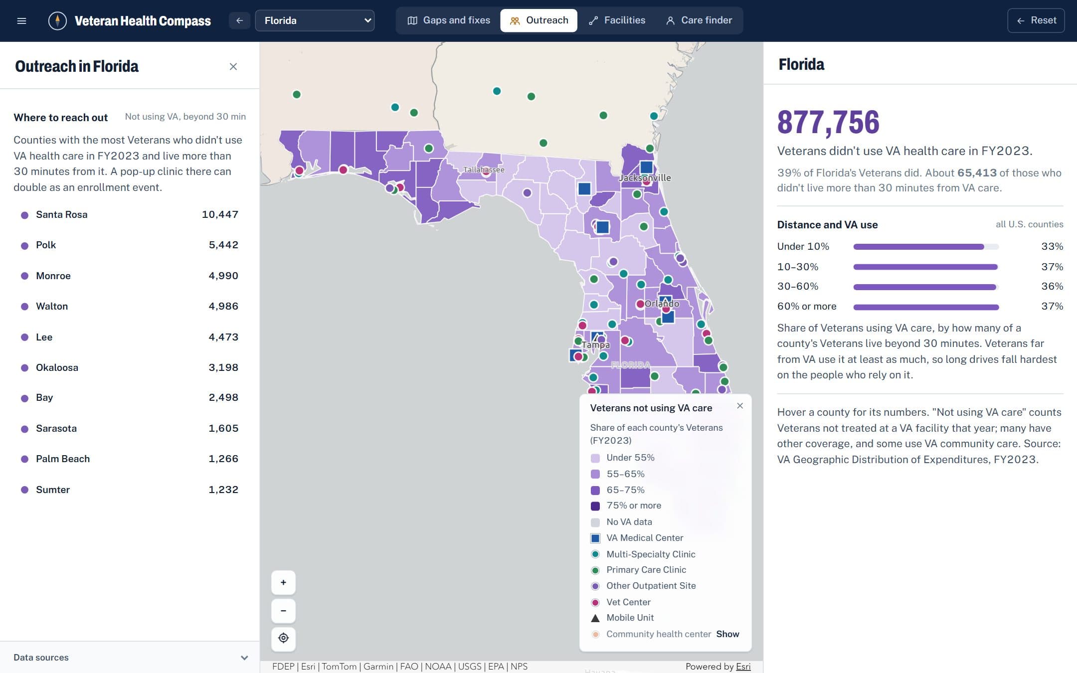
Find the Veterans VA isn’t seeing yet
Using VA’s FY2023 spending data by county, the Outreach map shows where Veterans who didn’t use VA care live and which of them are far from it, so a pop-up clinic can double as an enrollment event.
The story
A landing page that makes the case
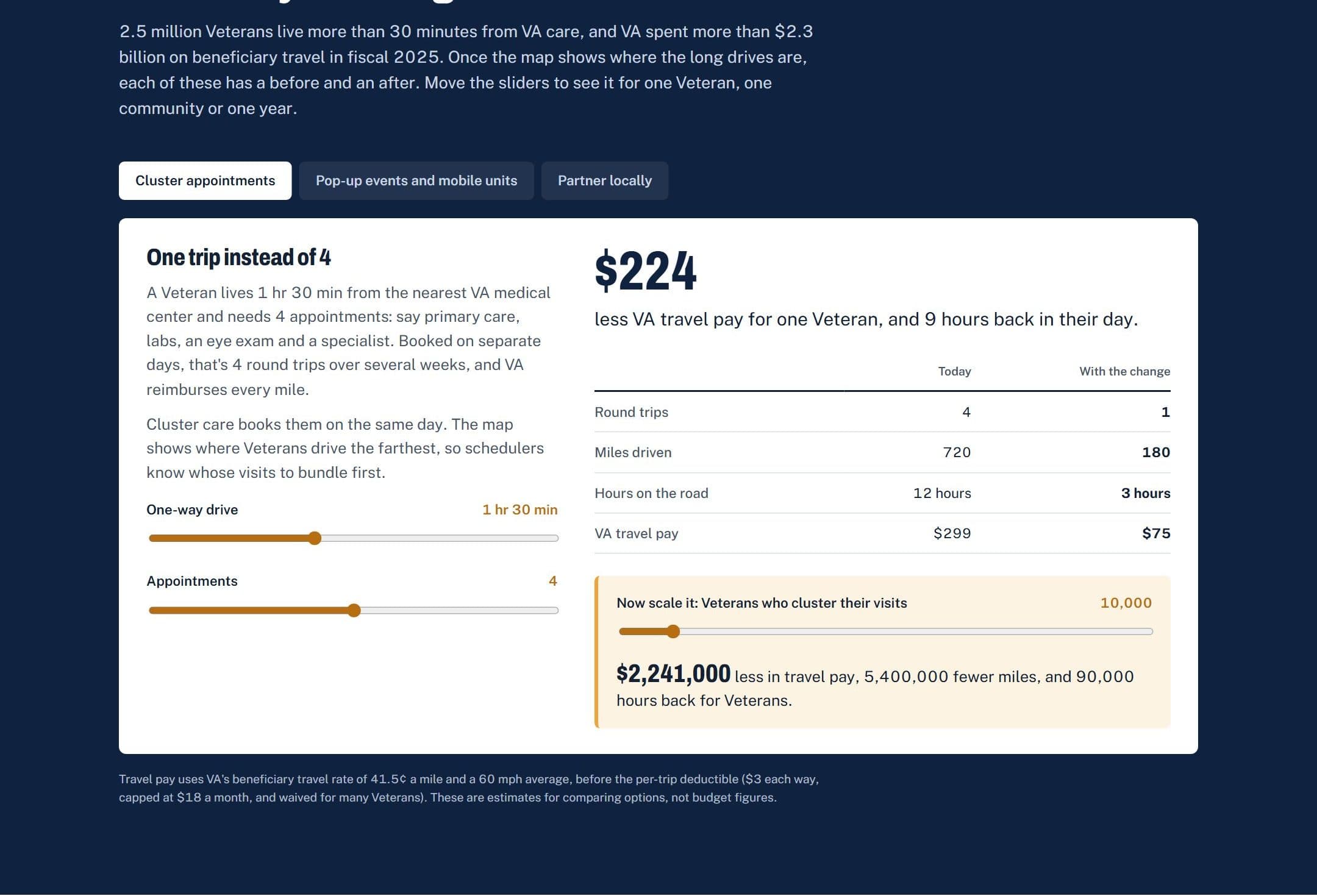
Before the map, the site tells the national story and lets visitors try each fix themselves: cluster appointments, pop-up events and mobile units, and local partners, each with a before and after.
Features
Built for the people who plan care
Real drive times
Road-network drive-time areas from ArcGIS, not circles on a map, for every VA medical center and clinic.
Before and after
Each proposed site shows how many Veterans it brings within 30 minutes, counted once when sites overlap.
Cost alongside reach
Upfront and annual costs for each option, with assumptions anyone can change to match local figures.
A planner with limits
Pick counts, spacing and a budget cap. The LLM can swap a site for a better one but never past those limits.
Care finder
Set a Veteran’s home and rank the nearest VA sites and community health centers by real route time.
Public data only
VA VetPop, the VA Facilities API, VA spending data, Census and HRSA. No patient data, no VA systems.
How it’s built
A static map app with a small planning service
Map app
- React 19 and TypeScript on Vite
- ArcGIS Maps SDK for JavaScript
- Works on phones, with tap-to-inspect
Data pipeline
- Node scripts build every state
- Census tracts to 2.5-mile hexes
- Drive times solved once, then cached
Planner
- Greedy placement by new Veterans reached
- An LLM reviews and explains the plan
- The browser re-checks every rule
Hosting
- Caddy on my own server
- A sitemap with every state’s map
- A small Node API for the planner
- Drive-time areas are solved ahead of time and shipped as static files, so browsing the map costs nothing; only a new proposal calls the routing service
- Veterans far from VA care use it at least as much as those close by (37% vs 33% across U.S. counties), so long drives fall hardest on the Veterans who rely on VA most
- The browser re-checks the LLM’s plan against the spacing and budget, and falls back to the planner’s own plan if it breaks a rule
See your state’s gaps
Open the map, pick a state and try placing a mobile unit or pop-up clinic where the drives are longest.